Hike Recap: Presidential Traverse Trail
Of all of the hikes I have done, the Presidential Traverse is my piece de resistance. It’s been over a month since we did it. I still think about it every day and I am completely amazed and thankful that my body carried me through the journey. Okay, I’m done being sappy for a little while. Here’s what our experience was like.
We took a half day from our day jobs so that we had plenty of time to drive up north. We thought about inviting others to join us on this hike, but when it came down to it we decided against it. Mike and I have been hiking together for so long, we know exactly what each other’s hiking style and ability are like. I knew that he could do this hike no problem, and I was pretty confident in my own abilities, so we decided to go it alone so that we wouldn’t have to introduce any unknown variables into the mix.
Speaking of unknown variables, we chose to bring two vehicles. Maybe there was a better way to do this that would use less gas. I’m sure there is a shuttle that takes hikers from one end of the traverse to the other. Uber would be another option. We thought that two vehicles would be the best option, though, so that’s exactly what we did. Mike left his car at Crawford Notch on Route 302. There is plenty of free parking along Route 302 and we didn’t encounter any issues leaving his car there overnight either. We left Crawford Notch around 4:30 pm and made our way to our Airbnb in Gorham, NH. On our way to Gorham we passed right by the Valley Way Trailhead/Appalachia on Route 2 in Randolph that we would be parking at the next morning to start our traverse.
We arrived at our Airbnb around 5:15 pm. We had a lovely stay with our host! Hub North is a very unique property. Fully stocked kitchen, plenty of room in the common area to hang out, nice bathrooms, REALLY nice, clean, and stylish bedrooms. We were in Room 2.


We booked our room for two nights, Friday and Saturday. We lucked out and had the place to ourselves (there is a total of four bedrooms at this property) the first night. I really wanted to stay in and cook the pasta that I brought for dinner, but Mike wanted to go out so we explored nearby downtown Gorham instead.
Along Route 16 in Gorham is a cool railroad bridge over the water. There is a small dirt parking lot that we pulled into and explored the area for a few minutes. We would have spent longer here however we had a very early morning coming up. We walked over the bridge, ate a quick dinner in town, and headed back to the Airbnb to shower and sleep!

My alarm went off bright and early at 4:00 am! We woke up exhausted. I had tossed and turned for most of the night because I was nervous and excited for the hike the next day. I made sure to tape my feet extremely well and we were on the road around 4:40 am. A beautiful sunrise sent us off.

We arrived at the Valley Way Trailhead/Appalachia just before 5:00 am. The parking lot was FULL. We got the very last spot and worked to make another spot for another couple in a very large truck from Maine. Parking is definitely tight in the lot however there is plenty of free parking along Route 2 near the entrance to the official parking lot. Parking in the lot was free as well.
We went back and forth over which approach to take. Valley Way or Airline. Airline or Valley Way. Truth be told, we didn’t make up our minds until we were AT the junction. We ended up choosing Valley Way using the logic that it would put us closer to Madison, the first peak of the traverse. Truth be told, I don’t think it makes a lick of difference whether you choose Valley Way or Airline. On a map they appear to be very similar trails, so we more or less flipped a coin and did the one that we did. If we do a traverse again, I’m sure we will choose Airline just to see what the differences are.
We purposefully took our time getting up to the ridge line. You do about half of your elevation gain for the entire hike in the first 3-4 miles or so, so we didn’t want to unnecessarily tire ourselves out when we would still have so much farther to go. This is a strategy that I would recommend over and over again.
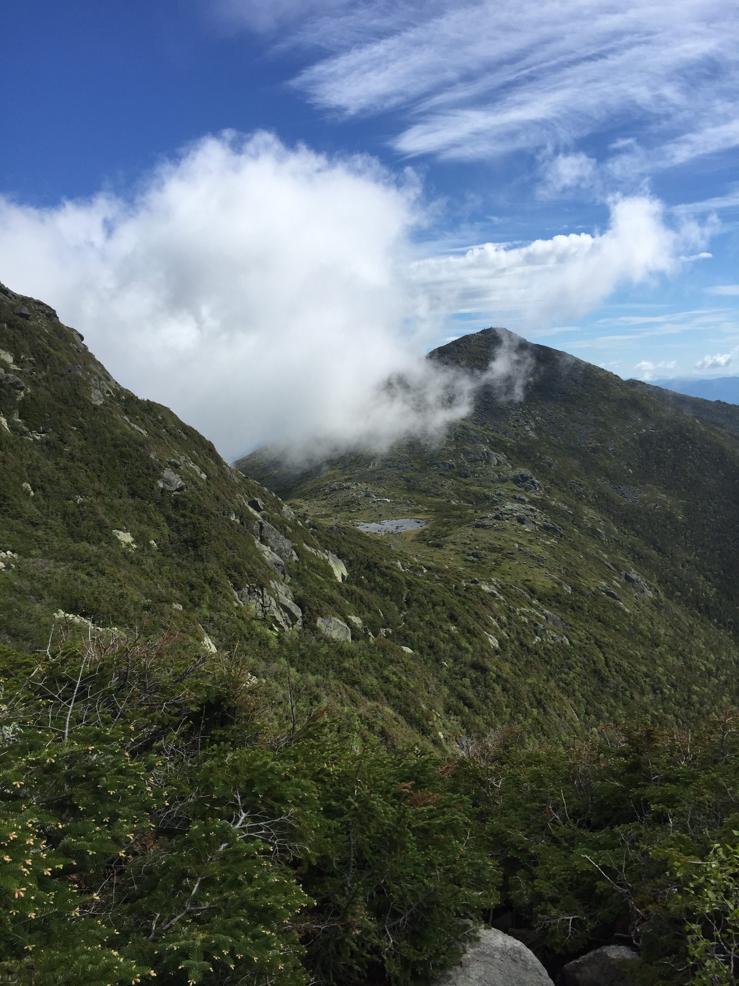
About two miles into our ascent, we arrived at a junction for Watson Path. We consulted the map because this is not a route we had previously considered. When we saw that it was a direct route to the summit of Madison, we quickly agreed that that was the route we would take. The alternative here would be to continue along to the Madison Spring Hut, climb a half mile to the summit of Madison, then retrace our steps back down to the hut. We decided that we did not want to do that, so we ascended to the ridge line via Watson Path. I did not find this to be a particularly difficult climb, however in sections it did remind me very much of the Adirondacks! Mike was in agreement. In no time at all, we found ourselves at the “worst weather in America” warning sign that we’ve seen so many times on our White Mountain hikes.

You know, it was kind of funny. We passed this sign around 7:15 am, came out from the cover of trees we had been hiking through into a giant rock pile, and the weather really did just clobber us. The insane wind that stayed with us all the while we were on the ridge line began here and never once let up until well after Washington. This made our final ascent to the summit of Madison a bit tricky, but we finally reached Madison around 8:00 am.


We didn’t stay long on top of Madison. After taking a few photos, we followed the cairns down to the Madison Spring Hut half a mile below. It was a descent of 541 feet. We stumbled into the hut absolutely freezing. I’ll probably say this 10 more times throughout this post, but like an absolute idiot, I neglected to bring gloves with me. What was I thinking?! It’s never a good idea to hike in the Whites at any time of the year without gloves. I won’t be making that mistake again.
Mike always hikes with at least one MRE. He opened that and started eating some food from it. I saw that there was some vegan chocolate cake for sale at the hut. Am I one to pass down chocolate cake, especially on a day that I’m burning thousands and thousands of calories? I’ll let you decide what I did here.
The cake was not delicious. However, it was calories where I hadn’t really had any yet that morning. So I sucked it up and wolfed it down.
We stayed at the hut for much longer than I would have liked, for the better part of an hour. We were both extremely cold and absolutely exhausted. Neither of us said it out loud, but at this point in the hike, a mere four miles in, we were both seriously doubting our abilities and we were not sure that we would finish the traverse as planned. I used the bathroom, filled up my water bottles, and tried to warm up as best I could. Most importantly, at the hut I took one 200 mg caffeine pill. I’m really not one for taking pills like this of any sort, but I was in serious need of a boost here. I think this was about the equivalent of two cups of coffee. I actually detest coffee of all kinds. Hot, iced, loaded with cream and sugar, mocha flavored things, coffee ice cream, if it’s coffee ANYTHING I’m just not into it. However, I do love my morning tea. I usually drink green tea, but if I’m feeling especially exhausted I will choose black tea instead. So, needless to say, this caffeine pill hit me HARD in the best possible way. I pretty much ran out of that hut like Speedy Gonzales and thankfully that energy stayed with me all day.
We had about a one mile climb and an ascent of 974 feet to the summit of Adams. Since I was high on caffeine we actually passed quite a few other hikers on this section of the traverse. The view of our ascent of Adams was my favorite view of the entire day. I was reminded of Europe here.

We reached the Summit of Adams at 5,799′ and, again, did not stay long due to the wind. It was also incredibly foggy on Adams, as the photograph above might suggest. We made our way down toward Thunderstorm Junction where we nearly got lost, as did one other group that we encountered. We pulled out the map and had a heck of a time trying to read it with the 70 mph wind gusts. We finally found our way to the Appalachian Trail and took it southbound toward Jefferson. We were now on the “Hiker’s Highway” and the going was easy for about a mile as we made our way toward Jefferson.

Then we hit a snow patch. We did this hike in late June and still there was snow to be seen. I guess I shouldn’t have been all that surprised. Four years prior when I hiked Washington for the first time also in late June, Tuckerman Ravine was closed due to snow. We moved to the side as some northbound through hikers who lived in the south made their way carefully across the snow patch. Mike crossed first, and then I got out my poles and crossed as well. Not surprisingly the snow was melting, so it was easy to get good traction going across this section. It was about 100 feet long or so, but a misstep would have been costly. To the left in the photo above was a pretty steep pitch for several hundreds of feet, and then it just dropped off to who knows where. I tried not to think about that as I crossed, and I made it across in no time. Looking back, this was one of the most nerve wracking moments of our traverse. Sometimes you just don’t know what snow is going to do.
We soon came to another junction splitting off the AT to summit Jefferson. It was a .3 mile gradual climb to the summit of Jefferson at 5,716′. There are many rocks on the summit of Jefferson making this a nice place to sit and rest for a while on a day that you aren’t getting blasted by wind gusts. I hear those days do exist in the Whites, but in my opinion they are few and far between. We didn’t stay long, but long enough to grab another summit selfie! After Jefferson, I had no more new summits on my New Hampshire 48 list as I had done all of the remaining official summits in years prior to our traverse. In a way it was kind of nice knowing what to expect from here on out.

From the summit of Jefferson we took another quick .3 mile trail back down to the AT southbound. Once back on the AT, we thought as though the mileage signs we were seeing were a bit wonky. I wish I had photos but I swear I remember seeing signs saying that it was 5 miles to Washington. Maybe I was delirious at that point. Maybe my vision was impacted by being high on caffeine. Looking at a map we decided that it couldn’t possibly be that far, but of course we soldiered on in the direction of Washington in hopes that the next sign had something a little more hopeful on it.
We soon came to a junction with a trail leading to Mount Clay to the left and the AT southbound going to the right. Again we deliberated for a few short moments which way we wanted to go. We decided to go up and over Mount Clay, an “unofficial” 4,000 footer because it lacks the prominence required. It was a relatively easy climb to the summit of Mount Clay at 5,533′. At the summit of Clay, Washington looked so close we could touch it. However, I’ve been here before, and by now I know that looks can be deceiving in the Whites. What looks so close can easily take an hour or longer depending on the terrain. We made our way back down to the AT southbound and this is where we were awarded with our first hail storm of the day. Not knowing what the weather was going to do, I asked Mike to pull out my rain fly and cover my pack. We also covered up our bodies as best we could to protect ourselves from the hail. I had my rain jacket pulled up over my head and fastened. I have no idea how, but the hail seemed to make a beeline for my right ear. Every time a piece nailed me in the ear, which was covered by my rain jacket, I went deaf in that ear for a few moments. If you’ve ever played Call of Duty and had a grenade go off while you were standing right next to it, you know the sound I heard so often throughout the day. Short complete silence, then a high pitched squealing until I regained hearing in the ear. So. Annoying.
As we continued our approach up Washington, the hail ceased but the wind picked up. The wind picked up so much so that I was concerned that my rain fly would be ripped from my pack, never to be seen again. My rain fly for my day pack does not have clips. I was surprised to see this and hadn’t really thought about it until then. I asked Mike to take off the fly and stuff it back in my pocket. Poor guy, but he was a good sport about it as he so often is.
We trudged on and on over the never ending pile of rocks that is Mount Washington. This part of the traverse honestly felt like hours. My favorite part of perhaps the whole traverse was the cog railway. As we were hiking up, there was a train coming down. I have a very odd affinity for trains, so of course I stopped and waved. I swear that at least half of the train smiled and waved back. Sometimes I think I’m five years old but for some reason this really excited me and gave me the oomph I needed to continue the climb through the wind to the summit of Washington. The trail takes you directly over the tracks and by that point you’re (really) almost there.


The summit of Washington at 6,288′ was WINDY, and that’s putting it mildly. I reached the summit shortly before Mike and beelined it right into the visitor center at the summit. I was so cold at this point and the visitor center felt amazing to warm up a tad and just get out of the wind. The visitor center has a wide variety of overpriced, sub-par food. But it was hot, it was already prepared, and it was there, so of course we took a few minutes to feast. I had chicken and rice soup and a hot dog. The soup was an excellent idea on a day like that and it was just what I needed. We feasted, used the restrooms, filled up our water bottles, and headed back out into the wind once again. We’ve both summitted Washington, so neither of us felt the need to stand still in line for 45 minutes waiting to have our picture taken at the summit sign. We often joke that there should be two summit signs, one for people who drive to the top and one for people who hike. That’s never the case though, of course.
We picked up the AT southbound once more with Mount Monroe in our sights at 5,372′. Going down, alright! On our descent from Washington we got blasted with yet another hail squall. The hail was the same size as the previous squall, so it was nothing we weren’t prepared for. We pretty much ran down the trail as the path was very nicely maintained and the rocks were the right size to allow us to do so. It was just over a mile from the summit of Washington to Lakes of the Clouds Hut at 5,012′. Lakes of the Clouds is an incredible spot. I didn’t have a chance to take a photo unfortunately as I was busy getting blasted by yet another hail storm. They aren’t joking when they say the weather on this trail is relentless.
We ran into the Lakes of the Clouds hut for another short rest. Mike decided to tape his feet here because he felt them getting a little blistered. In hindsight, I wish I had brought a change of socks because I would have re-taped my feet and changed my socks here. I don’t want to give any spoilers, but my feet were extremely waterlogged when I finally limped out of the woods that night.
From the hut it’s a short run up Mount Monroe at 5,372′. You have to go off the AT for a short while to take the Mount Monroe Loop trail over the summit of Monroe, but you pick the AT up again about .4 miles after the summit of Monroe. The next official summit is Mount Eisenhower at 4,760′. I have somewhat of a soft spot for Eisenhower after hiking it last summer for the first time. And I can always pick it out of a ridge line when I’m looking in that direction because it sticks out in my mind as being the most symmetrical peak in the area. Can you see what I mean? No? That’s fair.

It’s about two miles from the summit of Monroe to the summit of Eisenhower. It’s a relatively quick and easy two miles, however. The summit of Eisenhower at 4,760′ greets you with an enormous cairn. Like all of the other summits that day, it was far too windy at the summit to stay longer than to snap a quick photo and get the heck down. But it sure was cool to look back up the ridge line to see just how far we had made it so far that day.

After Eisenhower I was ready for this hike to be done. Perhaps it was because I wasn’t particularly fond of Pierce and Jackson when I summitted those peaks the first time last year. Perhaps it was because my knees were starting to ache and my feet were itchy and burning as they sometimes get after I’ve been on them for 15ish miles in one day. I think it was really more so that we were on Eisenhower around 6:00 pm and that’s usually about the time that I’m ready to throw in the towel on a day hike. I just wanted to shower and eat myself silly at a buffet with all the worst foods known to man. We still had so much farther to go and I knew it. So much of this hike is a mental game, and that really started to kick in for me as we made our way down Eisenhower.
We took the Eisenhower Loop Trail back down once again to the AT southbound heading a little over a mile to the summit of Mount Pierce at 4,312′. This section of the traverse has some wooden foot bridges. This year I didn’t have any issues with them, but last year we were on this section of the trail around 6:00 am and I seemed to struggle with them then. Perhaps I was still sleeping, but I remember slipping off to one side of the foot bridge straight into a mud patch that ended up topping my boot. It made for a wonderful hike out. Thankfully no such misfortune this time around! I guess I knew what to look out for now.

We had been on the Crawford Path since just south of Washington. We stuck with it for miles. However, it was time to say goodbye so that we could continue on the AT southbound to summit Mount Pierce at 4,311′ just south of the Crawford Path/AT junction. Continuing on the Crawford Path was one of our bail out options, which I will discuss later. Had we needed it, it would have taken us right back to our car on 302 quickly.

Looking back, I realize now that I had such a false sense of hope on the summit of Pierce, and I think Mike did as well. Seventh official summit. We only have one left. It will be a breeze, right? Wrong. SO wrong. After Pierce, we still had another 2.5 miles to the last summit PLUS the descent from the ridge line to look forward to.
We were making good time until we were about a half mile from the Mizpah Spring Hut. Just before the hut is a sharp descent. For the first time all day, my knees started to scream at me. Not bad seeing as I had come 17+ miles before any real pain started to set in. I can’t be mad at my body for throwing in the towel so late! We reached the hut at 3,777′ and I knew that I didn’t have a choice but to take some ibuprofen. I took a normal dose and we quickly continued on as we knew it would be getting dark soon. Still 1.6 miles to the next summit! I can’t lie, the luster of the traverse had died long ago and now we were just hiking to be done and be back to the car. It’s not a particularly difficult 1.6 miles, but it’s a tough 1.6 miles because you’re pretty wiped by the time you’re here.
We reached the summit of Jackson at 4,052′ at 8:10 pm. That sure was a beautiful sight to see. We stayed at the summit for 15 minutes or so to enjoy the sights from the ridge line one last time and to watch the sun set. I was mostly just postponing the inevitable: the descent from the ridge line back down to the car that I had been dreading all day. Just a little fun fact about me…I absolutely loathe hiking downhill. It just destroys my knees. The more I talk to fellow hikers, the more I come to realize that I am not alone. The consensus is that we’d all rather keep going up and never have to hike down. But as we know, what goes up must come down. After catching a few more glimpses of the setting sun, I got up and began the very long 2.5 mile descent down to Route 302.


At the summit of Jackson, you have two options. You can stay on the AT southbound for another 1.3 miles, or you can head down the Webster-Jackson Trail instead. Going down the Webster-Jackson Trail saves about a mile from the descent. At this point in the traverse, I have no idea who wouldn’t take the shortcut. I have seen some “official” trail maps of the Presidential Traverse that calls for the longer descent because that way takes you over Mount Webster. This is not a 4,000 footer and I’m not sure why this would be counted as part of the Presidential Traverse. It’s just ludicrous, so of course we opted for the Webster-Jackson Trail.
It doesn’t look all that steep when you analyze the topography, but trust me when I tell you that there are some tricky sections to this descent. It could also be because I just wanted to fall down and roll down the mountain to the car. I’m not sure. But I do know that it took us almost two hours to make it the 2.5 miles down to Route 302. I told you I don’t set the world on fire when I hike downhill! I’m sure inside Mike is probably exploding with impatience, but he’s always such a good sport waiting for me as I make my way gingerly down each boulder. We held out for as long as possible, but we had to break out our headlamps eventually. We had come too far to get injured in the last mile of the hike.

Look at that. I’m practically already sleeping.
We finally limped out of the woods around 10:00 pm. This trail spits you out to Route 302 on the southern side of the small Saco Lake. Mike’s car was on the northern side of the lake, so we walked along Route 302 for a short way to reach his car. Around 10:15 pm, we were feeling quite victorious as we collapsed into Mike’s car. We drove back to the northern trailhead to pick up my car, and the rest is history!
What you hear about this hike is true. It is an absolutely amazing hike through one of the most beautiful parts of America. Pictures cannot do this place justice. It’s an amazing experience, however it is not for the faint of heart. This hike requires a lot of physical preparation, of course, but a lot of mental preparation as well. I think sometimes people underestimate how difficult it will be mentally, but it is very important to be prepared for both as best you can be.
Now that I’ve completed a successful Traverse, I have a few tips to share with those attempting to make the feat.
- Be prepared, gear-wise. I would say that having the right gear is the most important part of this hike. You should have boots that have been broken in and are in good condition. You will need a backpack or a pack of some sort. I brought my usual 20 liter day pack and it was perfect. I found hiking poles to be of great assistance for this hike in particular. Hiking poles work to protect your knees and they also keep my fingers from getting swollen since my arms are at 90 degree angles most of the day instead of straight down by my sides. I did have to stow them away sometimes on some of the tougher climbs, but by and large they were in my hands for most of the day.
- Wear and bring appropriate apparel. Being comfortable is very important on this (and any) hike. I wore my recent favorite hiking pants I got at REI at the beginning of this season. For a shirt, I opted for my favorite cheap polypro florescent orange shirt that I’ve had for a solid decade now. I think it cost me about $10.00 and I can’t remember where I got it. A bird pooped on me on a run last year while I was wearing the shirt. The stain is still there, but it’s a great shirt so there’s no way I’m ditching it all because of a little poop. Wear good socks, and bring an extra pair. Learn from my mistakes. Let your feet dry out and treat your feet to a fresh pair of socks when they need them. My go-to socks of choice are always Darn Tough. You will also need a few layers to keep you warm once you reach the ridge, no matter what month you hike in. I brought another polypro long sleeve quarter zip top that I got on sale at an EMS a few months back as well as my Columbia rain jacket/windbreaker that I bought about 8 years ago. This was all I needed to keep my core warm. And definitely bring gloves! My hands were so cold I contemplated spending $35 at a hut to buy a pair of gloves. I didn’t end up coughing up the cash, but it was tempting. This advice rings true if you are attempting a traverse in the popular months of June through September. I really can’t comment on a traverse done in winter or spring as that’s not when I typically do most of my hiking. If you are attempting a winter traverse, good for you! Personally I would never, but more power to you. Please be safe.
- Water. If you are staying true to the traverse, you might not need to pack as much water as you might be thinking. Crazy thought, I know! But you will pass by three huts plus the visitor center on top of Washington, and all of these places have water free for the taking. I brought two Nalgene bottles and this was more than enough to get me from hut to hut. I never ran out of water. I think 2 liters is the sweet spot for having just enough water without carrying too much extra weight.
- Food. I wasn’t really interested in eating too much on this hike. Whenever I’m doing a long hike, I get in a mindset that I just need to HIKE HIKE HIKE. Obviously this is not exactly a strategy for success because rest and energy are important. Mike is very good at resting and eating on hikes, so he’s always encouraging me to do the same. Having a hot meal inside the visitor center at the top of Washington made a big difference for me, even if it was expensive. I would suggest definitely bringing money to buy yourself some food up there. Beyond that, I want the lightest but most calorie dense food I can find. Beef jerky is a good option. Larabars are good as well since they are basically a healthier version of a candy bar. I would also recommend nuts and fruit.
- Have several bail out routes planned, and don’t be too proud to use them if necessary. The weather may be perfect when you start the day, but as I often say, the mountains make their own weather. If you encounter bad weather, the most important thing to do in my opinion is to get off the ridge line. You also might be hiking quite a bit slower than you anticipated. We knew that this would be a long day and we figured we would be finishing the hike around 10. You may find that you are hiking considerably slower, and maybe you do not want to get back to the car at 3 in the morning. Bail out routes come in handy here as well. We brought a map with us, but we also spent quite a bit of time studying the map posted at the trailhead. We knew that we would make it at least up and over Washington, so we spent most of our time considering bail out routes south of Washington. Ammonoosuc Ravine Trail was an option for us, which is between Washington and Monroe. Edmand’s Path between Monroe and Eisenhower was another option if needed. Crawford Path just before Mount Pierce was our last thought. Thankfully we never had to use any bail out route, but I maintain that they are very important if you are planning your own traverse. You might see a sign posted at the trail head like we did that says something like: “Call Dave, I’ll bring you anywhere” with a phone number posted next to it. We took a photo of the sign just in case. You might be able to Uber back to your car if you have cell service. There is also a shuttle service in the area however I am not familiar with the schedule. The point is, have several back up plans and know when to use them.
- Extras. I don’t think it’s possible to have everything that you could possibly need on this hike. You’ll likely always be wanting for something. For me, that something was gloves and an extra pair of socks. Other than that, I was pretty set. Definitely bring a head lamp as most people start and finish this hike in the dark. Small containers of bug spray and sunscreen are recommended. I also brought sunglasses. Sports tape comes in handy if you feel yourself starting to blister. Even if you are preventative and tape your feet before you start I would still bring the roll. Cash is recommended for buying food at the huts. The visitor center at Washington also accepts credit cards.
- The before and after. I’m really glad we spent the $200 (total) to stay in an Airbnb the night before and after this hike. I never sleep well when we’re camping, so if we tried to camp I know I would have been even more exhausted at the start of this hike. It was also really nice not having to drive four hours home after we had hiked over 20 miles in one day. This hike was a bucket list item for us, so I was fine shelling out the money to be comfortable and get some good rest before and after this hike.
- Do not finalize your plans until the week of. As I mentioned above, these mountains truly make their own weather. We decided that we were doing this hike the Wednesday before we did it, a Saturday. We had been tracking the weather for the previous week and only decided on this when we saw there was a good chance that the weather would cooperate. We booked the Airbnb on Thursday. Of course with such late planning you run the risk of not finding a hotel, or having to pay more for one. We did get lucky there, but I wouldn’t have wanted to do this any other way because knowing my luck, we would have booked a room a month out and there would have been some freak weather activity that would have made it impossible to go outside. Sometimes the last minute is the best minute!
- That said, don’t hold off on this hike if you are waiting for perfect weather. You’ll likely only get a few days of the year of perfect weather, and what are the chances one of those days will just align perfectly with your hike? When we planned our traverse, there was something like a 30% chance of rain. Had we waited for a 0% chance of rain day, we never would have done this hike. Don’t count on perfect weather, but be prepared for unfortunate weather (wind, rain, hail, thunder) and have several bail out routes planned.
If you’re thinking of attempting the Traverse and you’ve already had some experience hiking some 4,000 footers in the Whites, my advice to you is GO FOR IT. This is truly a once in a lifetime experience that I will never forget and I’ll always be glad that I did. Let me know your own experience in the comments below!