Hike Recap: Mount Monadnock
I have hiked Mount Monadnock once a year for the last six years. It is a wonderful hike to do to introduce your perhaps not-so-outdoorsy friends and family to the wonderful pastime that is hiking. It’s centrally located in New England. It’s not technical and it’s not overly difficult. However, you end up with excellent views no matter what trail you take to the summit. And there are a TON of options to choose from! I’ll go over three different options here, but there are still several others if you’re in the mood to adventure.
Pumpelley Trail
I’m starting with Pumpelley first because it is my favorite! I hiked it first in 2017 and we liked it so much then that we decided to do it again this past weekend as well.
The trail starts on Lake Road/E Lake Road in Dublin, New Hampshire. There is no parking lot, but there is ample parking along the road. As of October 2019, there is no fee to park here. Roundtrip, this is anywhere from an 8.3 to 9 mile hike, depending on who you ask. Alltrails will tell you it’s 8.3 miles round trip but the sign at the trailhead will tell you it’s 9.

The trail starts off very gradual through the woods. It makes for a nice warm up for the steeper sections to come. The scenery is beautiful and if you go in the fall as we always do, you have the chance to see some very colorful foliage. About a mile or so in, you will come to a rock staircase. The staircase leads you to the steepest part of the hike, in my opinion. It’s wooded but quite steep and you gain a lot of elevation in a quarter of a mile or so. There are plenty of trees to hold on to along this section. It’s not anything crazy, just something to be aware of and take your time on.

Roughly two miles into the hike, to the right you will see your first glimpse of the summit. You can’t tell from the picture, but from this point you will be able to see people on the summit. If you go on the weekend as we usually do, it’s likely to be pretty busy. As is the case with most things, if you go during the week there will be far fewer people. I think the reason why Pumpelley is my favorite is because it’s by far the least crowded trail that I’ve done to the summit of Monadnock. The summit is crazy busy, but at least most of the way there and back you’ll have the trail to yourself for the most part.

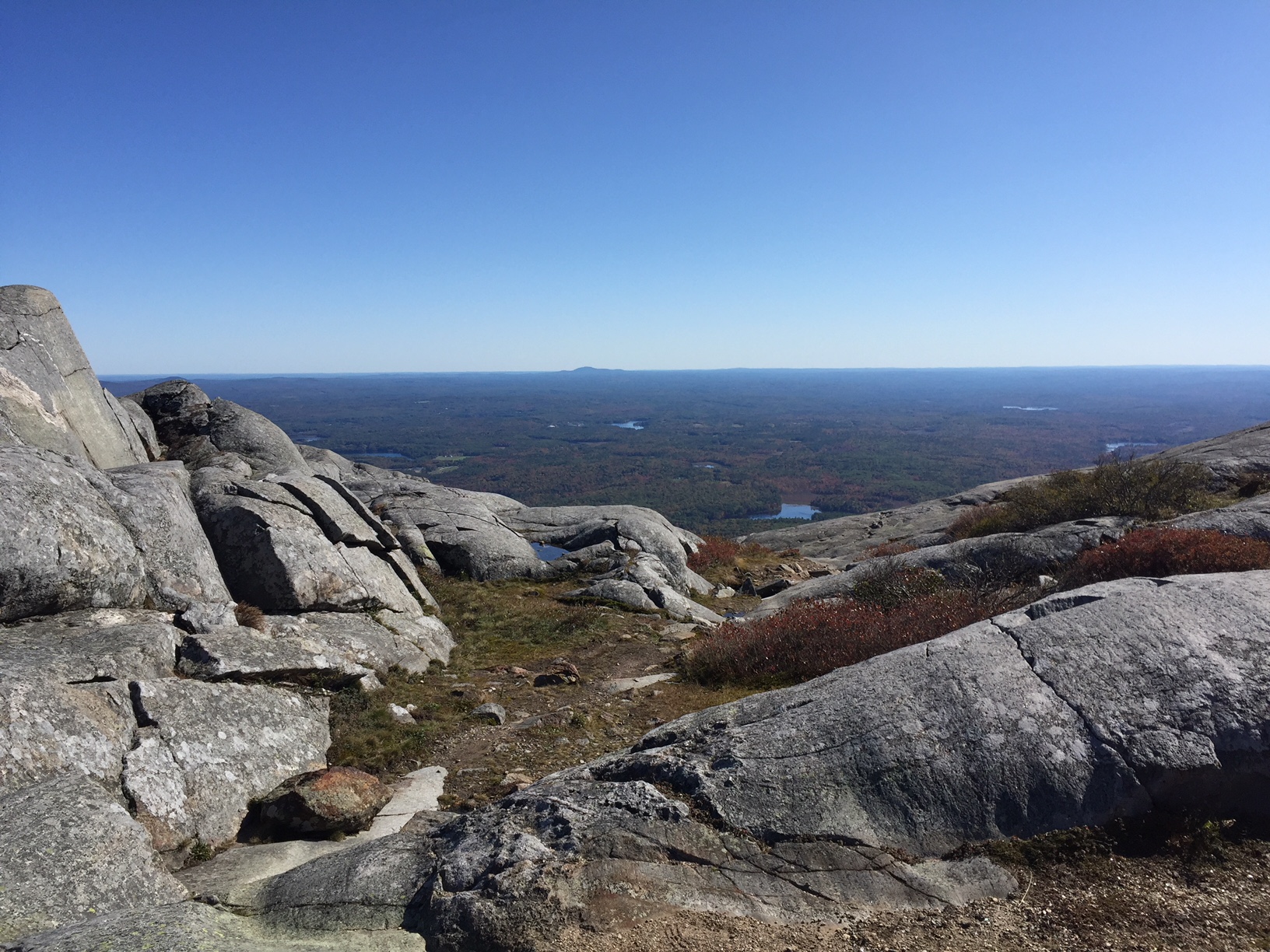
To the left will be views of mountains, towns, bodies of water, and, on a clear day, Boston.

And don’t forget to look behind you! I always like to see what we’ve done so far. We came up and over the knob in the photo and we started at the lake, which is just barely visible in the photo.

We walked another quarter of a mile or so and then were met with a nice view of the changing leaves on the trees just below us to our right. There were several areas to stop along the trail, walk out a ways, and take pictures.

Looking up the trail, the summit is slowly but surely getting closer!

You will come across a few side trails to your left, but do not take them as Pumpelley takes you all the way to the summit! The junction with the Red Spot Trail is the largest junction you will see if you hike Pumpelley Trail. This junction has a very large cairn with a wooden sign sticking straight out of it. Very difficult to get lost at this junction. Follow the signs up the mountain and you will be at the official summit in less than a half a mile.

Once you reach the summit area, there are plenty of places to sit and rest and a lot of interesting features to see. The summit sits at over 3,000′, so even in the summer it can be chilly up here. We lucked out this weekend and had beautiful weather the entire day. It was only slightly windy when we reached the summit. but I put on my windbreaker and gloves because I knew we would be at the summit for a little while to eat, drink water, and rest.

Once you’re done hanging out on the summit, you simply retrace your steps, staying on Pumpelley again the entire time, until you reach your car!


White Cross/White Dot
White Cross/White Dot is the busiest trail to the summit of Monadnock. I’ve done it three times and it seems as though it gets busier every time. I think it’s the busiest because it’s the shortest route to the summit; round trip, Alltrails claims this hike is a total of 3.7 miles. It certainly does not take long at all. The trailhead is located at a campground. If you make the mistake and get here late on a weekend in the fall, you’ll have a bit of a walk through the campground and a lot of traffic to get to the trail. Apart from this route being basically a highway of people, they also charge you $5 per person to hike the mountain. I’m just not into it, so I don’t know that I would take this trail again on future trips.
Despite all of the things that I personally dislike about this route, since this trail is much shorter than Pumpelley, this might be a slightly better option for beginners. It’s easier to sell a new hiker a ~4 mile hike than an ~8.5 mile hike. The elevation gain is a few hundred feet less than Pumpelley as well. There is some more scrambling on this route, but when the trail is dry you’ll be fine if you have boots or shoes with good tread. Plus, the scrambling sections will be especially satisfying to new hikers.
Old Halfway House Trail
This was the trail I hiked with my sister when I hiked Monadnock for the first time ever, in September 2014. This was before I met Mike and therefore before I got really in to hiking. This is another great option for Monadnock, in my opinion, and it is less busy than White Cross/White Dot. Old Halfway House Trail offers a very gradual start. You can follow Old Halfway House to White Arrow Trail that will take you directly to the summit. This is not what we chose to do, however.
We opted to take Old Halfway House Trail to Cart Path, where we took a left and followed Cart Path for a short time before taking a right on Royce Trail. We wanted to go up and over Monte Rosa. We took a left on Monte Rosa Trail but then opted to go right on to Fairy Spring. This was a very short trail but we thought it was aptly named. I remember going through the forest, crossing over streams, looking at all of the moss covered trees and rocks and thinking that this was what I always see portrayed in Disney movies where fairies, trolls, elves, etc. live. It was unique and different and I would definitely suggest it if you hike Monadnock on this side of the mountain.
Fairy Spring leads you back to Monte Rosa and after a quarter of a mile or less you will find yourself at Monte Rosa itself. This is a nice spot and the views are incredible on a clear day.

As you can see from the sign, you’ve still got another ~600′ of elevation to climb until you reach the true summit of Monadnock. From Monte Rosa, we took Great Pasture Trail to Smith Summit Trail which, as the name suggests, will take you straight to the summit in about a mile.

Once you’re done hanging out on the summit, there are several options to take you back down the mountain. You can always retrace your steps, or you can choose to go down a different way. When I did this hike with my sister, we began our descent via the White Arrow Trail. Instead of staying on White Arrow the entire time, we chose to branch out a bit. I wouldn’t put money on it, but I believe we took Ampitheatre to Cliff Walk. I don’t remember what exactly we did after that, but I remember the hike down being nice and scenic much like the hike up was. It was nice to get somewhat of a change of scenery. I do enjoy hiking loop trails for that very reason.

Regardless of the trail you take, Monadnock is a wonderful New England hike that I think everyone should do at least once. Keep in mind that there are no dogs allowed on any trails on Monadnock. Even though you can’t bring your dog, it’s a great hike for kids!
I encourage you to consult Alltrails before you plan your trip. There are so many great trails to choose from, it’s hard to pick just one! I hope this recap gives you a bit more ammo to help you plan your trip!
Have you hiked Monadnock? If so, what is your favorite route? Let me know your thoughts in the comments below! Happy hiking, friends!