Hike Recap: Kilkenny Ridge Traverse
If you’re thinking of hiking a Kilkenny Ridge Traverse, maybe don’t. Just kidding. Now that it’s over I can say I had a great time, but don’t underestimate this trail. It is a TOUGH one that doesn’t get a lot of foot traffic other than moose, as evidenced by the piles of excrement roughly every five feet. But the views were unlike any I’ve ever seen in the Whites, and that made this hike worth it in itself.
We decided to do this hike north to south. Our friend Pat parked at the southern terminus, the Starr King Trailhead, just off Route 2 in Jefferson, NH. He hired a car to bring him to the northern terminus. Mike had to work that day, so we weren’t able to leave for NH until about 4:30 that afternoon. We stopped for pre-hike burritos at Mesa Verde in Greenfield, MA and then were on our merry way.
I had heard rumors that there is a gate at the northern terminus of this hike, and that gate is closed from 8:00 pm until 10:00 am. I can’t confirm the exact hours firsthand, but I can tell you that when we pulled on to South Pond Road in Stark, NH after 9:00 pm we were promptly met by a very locked gate. Womp womp. Oddly, I thought briefly of backing out of the hike altogether, dropping Mike off to fend for himself, and then going home to binge watch Selling Sunset in silence and air conditioning all weekend. But after five seconds I realized there was no way I was driving 8 hours round trip to NOT hike, so I put on my big girl panties, found a parking spot, and geared up. Maybe 50 feet or so before the gate is a very small parking area enough for about 4 cars, likely for this exact purpose. So I pulled in, we got ready, and were on our way about 20 minutes after we arrived.
Once past the gate, it’s about a mile of easy paved road to the South Pond Recreation Area. Once you reach the recreation area, walk through the parking area and toward the pond. The entrance to the trail is toward the back right of the beach. You’ll walk along the pond for a little bit before the trail splits off and starts to head away from the pond. After a short way, there will be another split to the right that will take you to a half mile trail to Devil’s Hopyard. Since it was completely dark and past 10:00 pm at this point, we decided to forgo the Devil’s Hopyard side quest and we carried on straight.
I honestly can’t tell you what the next 3.5ish miles of trail were like since it was dark and the trail was buried under brush for the vast majority of our hike in to Roger’s Ledge that night. I do remember there barely being a trail and a few small stream crossings within the first two miles. We then passed through a bog where we had to be careful with our footing because there were several large holes where it looked like perhaps moose had fallen through. We didn’t see any moose, but if there were moose to be seen on this trip this is where I would have expected to see them.
We entered back into the woods for a ways where we passed an old town line marker. There was another climb, a nice meadow, another wooded climb, and then at long last we saw the glow of Pat’s campfire! We had left my car about five miles ago and it was now after midnight, so we were quite pleased to see a friendly face. We set up our sleeping situation for the night and then went to sleep.
I woke up before the boys per usual and decided to check out a nearby overlook. It was absolutely beautiful! I’ve never hiked in such calm weather. There was zero wind all night long and the morning was completely still as well. The boys finally woke up around 6:45 and we started packing up to head out. Before we left we all checked out Roger’s Ledge which is definitely a sight to see along this trail. There aren’t too many views on this trail, so definitely make sure to go out on to Roger’s Ledge to get a good look of what you’ll be climbing over the next couple of miles.


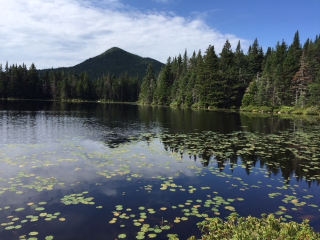
From Roger’s Ledge, the trail descends for about a half mile to Roger’s Ledge Tentsite. After the tentsite is a 2.1 mile stretch of trail that brings you eventually to Unknown Pond. This 2.1 mile stretch brings you first through Kilback Pond, a small body of water you will hike straight through that has some very worn footbridges that demand very careful foot placement. It’s only a short section, however, and if you pay attention you’ll be back on solid ground in no time. During this stretch of trail is a pretty decent climb on a very narrow and overgrown trail. You will see many, many more areas like this on this traverse, so this will give you a little taste of what is to come. You’ll reach Unknown Pond eventually, the trail to the tentsite first and then the actual pond.


When we hiked this traverse, water was pretty scarce to say the least. We decided to pump water at Unknown Pond even though it was questionable in terms of water quality. Mike’s water filter got clogged several times which slowed the process, and then he used iodine tabs on top of it. Pat and I didn’t tab our water and a week later we’re still alive and walking around, so I think it was probably fine even if it seemed a little questionable at the time. While I was filtering my water, the tiniest frogs I have ever seen kept hopping up to me to see what I was doing. I was LOVING this. This picture doesn’t fully portray how cute and small these frogs were, but if you ever make it to Unknown Pond, be on the lookout for these adorable little critters! After a nice long rest at Unknown Pond, we continued on up the trail in the direction of Mount Cabot.

After about a mile and a half we came to the junction for The Horn. Pat was pretty decided that he wasn’t going to go up, but I wanted to because I heard that was one of the few opportunities for views on the trail, and I’m a sucker for a view. When Mike caught up with us the three of us decided we would all check it out together. We ditched our packs and headed up the short .3 mile side trail to The Horn. It required a little bit of scrambling to get up onto the higher rock formations, but without our 30 pound packs we were all feeling quite agile. Once at the top of the rock formation, the view was pretty nice indeed. We could easily see The Bulge, which we would be hiking next, and the summit of Cabot just after that. Certainly worth the .3 mile detour. We didn’t stay long, however, and quickly made our way back to the junction to retrieve our packs.


There was a little bit of a climb over The Bulge and up to the summit of Cabot, but nothing crazy. The summit of Cabot doesn’t offer anything wonderful in terms of views, and it was pretty crowded when we got there, so we continued on the roughly half mile down to Cabot Cabin where we rested for a bit and aired our feet out. That was badly needed. I had taped my feet that morning, but when we got to Cabot Cabin and took our shoes and socks off, the tape slid right off since my feet were so sweaty. Lovely, I know. After our break was up, I decided I wasn’t going to re-tape my feet. I wanted to see how they would do and they held up pretty well for the rest of the day, blister wise.

Just a heads up, Cabot Cabin looks like it’s frequented by a serial killer. It’s probably not, but I’m just saying it’s terrifying inside. And it smells awful. At one point Mike said our plan was to camp there on one of the nights. It didn’t make sense logistically for us, so I said let’s not plan for that, and I’m really glad that we didn’t after seeing the inside of the place. I guess if you’re out there in a blizzard and it’s either staying in the cabin or dying as your two options I’d probably pick the cabin, but I’m just saying. Don’t plan on staying there if you can help it. It can comfortably sleep four, or eight in a pinch. How many live to see the next day is anybody’s guess!

After Cabot Cabin, you’ve got a little over a mile descent until you reach Bunnell Notch Trail. There’s really nothing noteworthy in this section of trail. There’s a short trail to a marked viewpoint, but I checked it out and it wasn’t anything spectacular. This section of trail isn’t tough, just a constant downhill grade until you reach the next trail junction. Once at the bottom you’ll take a left to head onto Bunnell Notch Trail. You won’t be on this trail long at all until you reach the next junction. Pay attention, because we thought the signage at the junction to continue on to Kilkenny Ridge Trail was a little confusing, and we actually ended up going the wrong way (continuing along Bunnell Notch which we weren’t supposed to) for a short while until we released our mistake and then had to backtrack.
Bunnell Notch Trail is a pretty well worn section of trail because most hikers summit Cabot in one day, and I think a lot of them make a loop out of it. This loop starts and ends on York Pond Road. The loop is actually a triangle and the route is Unknown Pond Trail, Kilkenny Ridge Trail, and Bunnell Notch Trail and then you’re back at your car. It’s around 12 miles, so definitely doable in a day and quite a bit easier since you can do it with a day pack. If we were doing this as a day hike instead of a backpacking trip, this is the loop I would do. But I digress.
Once back on Kilkenny Ridge Trail, it’s a three mile long section until the next junction. On this section of trail, you have a short (but not exactly easy) climb up to Terrace Mountain. Once you reach North Terrace Mountain, you’ve reached my favorite section of this entire hike. The trail gets pretty creepy here, I won’t lie, with a lot of dead trees and TONS of old man’s beard. It’s a truly unique experience to hike through as the narrow trail meanders through this quiet section of forest.


There are three little peaks in this section of trail, and then the trail takes a sharp left to descent from Terrace Mountain. There was a short spur trail at the junction of the descent to Terrace mountain proper, and I wish I had checked it out to see if there was any kind of view from this trail. Looking at the map I see there might have been views of Mount Weeks and Mount Waumbek, but I guess I’ll never know. My feet were starting to get tired at this point, so we all chose to descend instead of go the extra .1 mile to the summit of Terrace Mountain proper. If you do this hike and you went the extra distance, leave a comment and let me know if I missed anything! 🙂
After about a mile long descent, you end up at Willard Notch. The yellow blazes kind of just stop at a certain point during this section before the junction, but you can easily tell where the trail goes, so just keep following that worn footpath. Just before Willard Notch we passed over a very small stream that, although small, was still trickling a little bit. As you may know, when you’re looking for a water source to filter from, some natural movement in the water is ideal. Since this trail had been so dry, we thought this might be our last (and mind you, it was only really our second) opportunity to filter water. I was down to about a liter, and the guys didn’t have much either. We still had a night of camping and 10 full miles back to the car, so we decided we needed to filter more water here so that we didn’t have any issues with thirst for the remainder of our trip. We filled up and headed out.
I think there are some places to camp around Willard Notch. Many people who make a two night trip out of this traverse will camp in the Willard Notch area. However, we were staring a 1200′ climb right in the face, and we decided that that’s not how we wanted to start our morning. Our goal was to make it up and over North and Middle Weeks, because there is a saddle between Middle and South Weeks that we thought we might be able to camp in.
Having 3 full liters of water is great and all, but it made that 1200′ climb in one mile really challenging. I was tired before that climb, so when I rolled up to the summit where Mike and Pat were waiting for me what seemed like days later I was pretty burnt out. At that point it was after 7:00 pm and I told them I wanted to prioritize finding a spot to camp for the night as opposed to trying to crank out a few more miles. The summit of North Weeks is really serene and beautiful. There are tall grasses and it was pretty flat and very calm. There is a small side trail off to the left that Mike checked out, and he said there was a small clearing that was well on its way to being a pretty established campsite. That was an option. I sat on a rock for a few minutes to rest my feet, and between the three of us we decided to descend North Weeks and then reassess the situation. Pat declared that at 7:45 he was going to start looking for a campsite, wherever we were.
The descent from North Weeks was pretty tough after a full day of hiking like we had already done. There were a lot of downed trees in this section that required us to go over, under, or around. After 20 minutes or so, the trail started to level out for a little while. Pat was a ways ahead of us and then all of a sudden, I was looking at another steep climb and also Pat heading back towards us. I knew that I was looking at the climb to the summit of Middle Weeks, and I also knew that I really did not want to climb that mountain before settling down for the night. At this point it was 7:45, and Pat declared that he was scouting for a campsite. He quickly located something that might work, and we headed off the trail and into the woods to set up camp for the night. It was still light enough to gather some firewood and set up our sleeping arrangements for the night, so we did just that. Once we were all set up, we ate dinner and passed out pretty promptly around 9:00 pm.
We didn’t quite reach our goal of camping between Middle and South Weeks, but we were all glad we had that tough 1200′ climb behind us. Descending North Weeks and camping in the saddle between North and Middle Weeks was just an added bonus, and less we had to hike on Sunday morning. Every time I have a full weekend long hike like this, the goal is always to make the hike out on Sunday as short as possible, within reason. We do this because we know we’ll be very tired, and we still have a ~4 hour drive back home after we’re done!
It was another completely still evening with absolutely no wind whatsoever. Surprisingly, this makes it difficult for sleeping because the silence is a bit deafening. I tossed and turned the entire night and watched the clock, waiting for the first signs of daylight. Pat set his alarm for 5:00 am, which delighted me because I thought we would get on the trail bright and early. Pat pressed snooze, of course, and I finally got up by myself around 5:30. I noticed that the sunrise was pink, which alarmed me because of our Devil’s Path attempt earlier this summer. A pink sunrise usually means that bad weather is on the way. I started packing my belongings up around 6:00, at which point Mike and Pat also decided to wake up for good. We were back on the trail at 6:45 am, and our first task was climbing Middle Weeks. It wasn’t a difficult climb, but was just enough to wake us up and get us going for the day. Before long, we were up and over and in the saddle between Middle and South Weeks. Looking around, I didn’t see a lot of great options for camping, but if we had to stay there for the night I’m sure we could have found something in a pinch.

Up next was the climb up South Weeks. This doesn’t look like much on a map, but this section of the trail tired me out quite a bit. Same shenanigans, super narrow and overgrown trail, tons of downed trees, lots of moose poop. But this section of trail did boast a lot of fresh wild raspberries, so we feasted on those for breakfast and had a lovely time doing so. On our ascent we passed two trail runners heading in the opposite direction. We later found out that they started at the Starr King Trailhead, so they were making fantastic time in my opinion. Once up and over South Weeks, you have a final climb to the ridgeline that will take you up and over Waumbek, and then Starr King.
The climb up to the ridge is short, but once you’re on the ridge you feel like you’re on it for miles and miles. In reality it’s about one mile, but the terrain is tough and overgrown, so it takes quite a while to reach the official summit of Waumbek. All of a sudden you come to a clearing and there is a nice viewpoint off to the left. At this point, you’re only about a minute or two from the official summit of Waumbek. If you’re looking for a view, make sure to pull off here before continuing on, because there are no views from the summit of Waumbek whatsoever.

We reached the summit of Waumbek at 4,006′ at 9:00 am, which I was very pleased about. I sat down for a bit and drank a lot of water and ate a bar. Pat took off not long after I arrived. I hung out for a bit, and then continued on to Starr King. Once you reach the summit of Waumbek, it’s like Hiker’s Highway until you reach the southern terminus of this traverse. It’s a real treat, in comparison to what you’ve done so far. It’s a short ridge walk, more or less, to the summit of Starr King at 3,914′. Starr King has an old stone chimney on its summit and just above that, a small clearing where it looks like people have likely camped in a pinch.
We continued on, at which point Pat informed us he would see us at the car. It’s about 2.5 miles from the summit of Starr King to the trailhead, and once again, it was easy street for us. The trail is wide and well maintained since the vast majority of people hiking Waumbek do it as an out and back from the Starr King Trailhead. We passed plenty of day hikers heading up the trail as we were heading (read: basically limping at this point) down it. Before long we were able to hear traffic and we knew we were close. All of a sudden we saw a large clearing in the trees that I knew must have been the parking area. And before long, CARS! Always a beautiful sight to see after two nights and one very long hike in the woods. We were back at Pat’s car at 10:40 am. I was hoping to be back to his car for noon, so once again, I was very pleasantly surprised with our time. He drove us back to South Pond Road, and then we headed home!
The Kilkenny Ridge Traverse is a very tough trail that will bring you the long way up and over New Hampshire’s northernmost 4,000 footers. Check the weather before you head out, because this trail especially would have been absolutely miserable in the rain because the trails are so overgrown. We would have been soaked through to the bone in five minutes in bad weather. Good weather is a must, and still this traverse is extremely challenging. Overall, this trail is a great one to choose if you’re physically up for it and want to spend a weekend largely alone in a beautiful area of the White Mountains. Now that it’s over, I think I can confidently say I would do it again one day if I had a friend who wanted to! Who knows. Maybe by then some of the blown down trees will have been cleared away. More likely is that even more will be blown down instead!
If you have more specific questions that I can answer, drop them in the comments below. And if you’ve also hiked the Kilkenny Ridge Traverse yourself, I want to hear about your experience! Let me know!